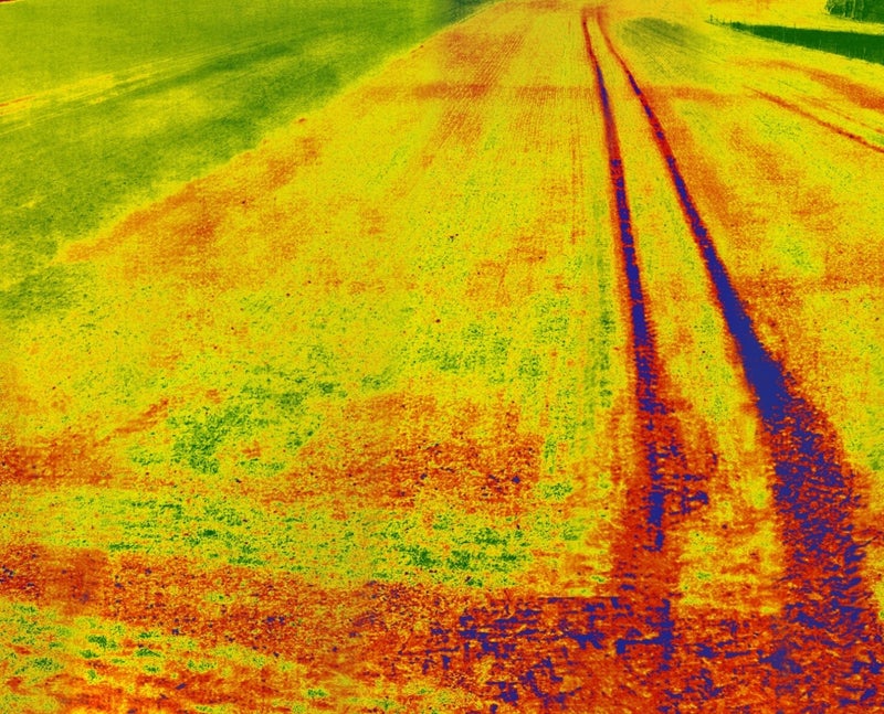
On-the-fly Crop Monitoring
Our advanced camera significantly transforms versatility by seamlessly processing Normalized Difference Vegetation Index (NDVI) imagery directly onboard drones with impressive speed and accuracy. Within just seconds, it generates highly detailed NDVI maps, providing instant and actionable crop health insights while precisely identifying problem areas that require attention. In addition to its powerful NDVI capabilities, this cutting-edge device boasts an intuitive and user-friendly interface, along with broad compatibility with most drone platforms, ensuring effortless operation and streamlined data management. Its rugged and durable design guarantees consistent reliability even in challenging and diverse environmental conditions, making it an essential tool for agricultural experts, environmental researchers, and passionate drone enthusiasts alike.
Stationary Crop Monitoring
The Rapid Eye XS is highly versatile and can be conveniently mounted on a stationary pole in the field or securely installed on the ceiling of a greenhouse, providing flexibility for various applications. Additionally, its lightweight yet exceptionally durable construction ensures ease of installation while offering dependable, long-term reliability across a wide range of environments. Whether utilized in harsh and demanding outdoor conditions or in carefully controlled indoor settings, the Rapid Eye XS is expertly designed to endure the elements and deliver consistent, top-tier performance. This makes it an ideal and dependable solution for agricultural professionals, researchers, and anyone seeking reliable, high-quality functionality in diverse situations.
Mobile Pole Monitoring
The Rapid Eye XS can be easily mounted on a 12-meter carbon pole, allowing for mobile crop monitoring by simply walking through the field. The camera's live video feed can be viewed in real-time on any mobile device conveniently positioned at the bottom of the pole. Photos can effortlessly be taken using the included remote control for added convenience. This setup delivers a high perspective NDVI map that provides an immediate and accurate view of crop conditions in real-time, making it perfect for scouting variability and identifying stress patterns across the field. The images captured with this system can also be processed into highly detailed aerial maps for deeper and more comprehensive analysis. It’s an incredibly simple, lightweight, and efficient solution that offers rapid, field-level insights without the hassle or expense of deploying a drone.
Crop Monitoring Training
The Rapid Eye XS is a highly compact and exceptionally user-friendly tool designed specifically for training in crop monitoring. It empowers users to visualize crop conditions immediately, whether from a stationary position or seamlessly on-the-fly when mounted on a drone. Its straightforward and intuitive design makes it an excellent choice for capacity building, providing a practical, hands-on approach to understanding vegetation patterns and field variability. The Rapid Eye XS is purpose-built to support practical learning experiences, delivering immediate and clear visual feedback directly in the field for better insights.
Key Features

User-Friendly Operation
The Rapid Eye XS is meticulously designed to deliver ultimate user convenience. Featuring a seamless single-button launch and a highly intuitive control system, it ensures effortless operation that’s perfectly tailored for both seasoned professionals and first-time users alike, making it an ideal choice for anyone seeking simplicity and efficiency.

Onboard NDVI Processing
Our versatile camera stands out with its exceptional and advanced capability to efficiently process Normalized Difference Vegetation Index (NDVI) imagery directly onboard. In just a matter of seconds after capturing an image, it produces a detailed NDVI map, providing immediate insights into crop health while precisely identifying potential problem areas.

Real-time In-field Advisory
The Rapid Eye XS allows for the swift download of NDVI maps directly to mobile devices via Wi-Fi or Bluetooth, delivering real-time, in-field insights for farmers and agronomic pilots. With its intuitive color-coded maps, users can effortlessly pinpoint healthy areas, detect problem zones, and make smarter, data-driven decisions to optimize crop growth.


